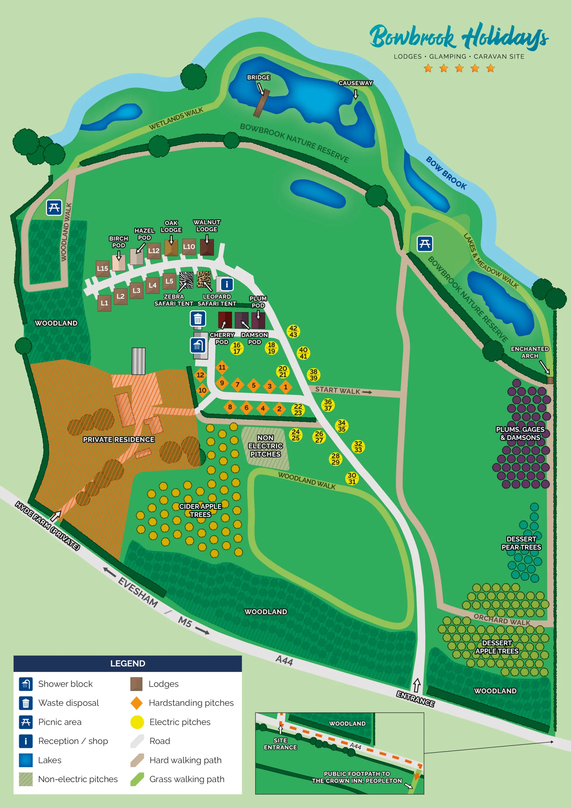
Great local walks
Bowbrook Holidays is set in the beautiful countryside and we’re lucky enough to be surrounded by great local walks in Worcestershire, Gloucestershire, Herefordshire and Warwickshire.
Whether you are looking for a long hike, a short ramble or a potter round a town centre, there is something for everyone.
Here are just a few of our favourites…
Bredon Hill
Located in the Vale of Evesham in Worcestershire, Bredon Hill is both beautiful and steeped in thousands of years of history. At the summit of the hill is an Iron Age hillfort, dating back to well before the 1st century AD.
The hill also boasts the earthworks of a once significant medieval castle, located next to The Dingle. When the castle was abandoned, the stone was used to build Pershore Bridge, leaving only earthen mounds to show that it ever existed.
At the summit of the hill is Parsons Folly (or the Banbury Tower), built in the 18th century as a summer house for John Parsons, the squire of Kemerton Court.
The hill has a number of well-defined trails, with excellent views on a clear day. The Elmley Castle picnic spot is particularly lovely for a bite to eat outdoors and is located just off Kersoe Lane.
There is no single large car park for Bredon Hill. Trails start from different locations, which can be accessed from a number of the surrounding villages. There are six villages surrounding the hill, most of which have some car parking either in designated areas or on the streets.
We would suggest parking near The Star Inn in Ashton Underhill and then walking up through the church.
The Malvern Hills
Whether you're looking to walk the whole length of the ridge, a place to walk your four-legged friend or a gentle stroll, the beautiful Malvern Hills and Commons has something for everyone.
Views from the Malvern Hills are stunning on a clear day. While the main ridgeline and the slopes of the Malvern Hills are steep, there are also alternative options if you're looking for a gentler walk or access for families or wheelchair users.
Whilst walkers have a right of access across all land under the care of the Malvern Hills Trust, walkers are asked to keep to established paths wherever possible, in order to minimise disturbance to wildlife or grazing animals. There are some restrictions in place for the safety of walkers and to protect some of the sensitive wildlife and heritage areas on the hills.
There are a number of car parks available close to the hills and we would suggest parking near The Kettle Sings Tea Rooms in the heart of the Malvern Hills. The Kettle Sings has its own spectacular views and is a great place to stop for lunch or a piece of cake before, during or after your walk.
Cleeve Hill
Cleeve Hill, a few miles outside Cheltenham, is the highest point in the Cotswold Hills.
If you fancy a long walk, it is part of the Cotswold Way, which runs all the way from Chipping Campden to Bath. But it is also a nice place for a bracing walk in its own right – the wind is always strong on Cleeve Hill, whatever the weather at the bottom of the hill!
The biggest car park is an old quarry close to the golf club. From here, take a walk up to the Three Sisters – the large pylons which can be seen for miles around. When you get to the top of the hill, it is surprisingly flat and free of mud.
There are a few benches to sit and enjoy the view, or take a picnic blanket. On a clear day, you can see as far as the Severn Bridges and the Black Mountains in Wales.
The area is shared with a golf course, so it is important to always stay alert to golf balls, not to mention the sheep which graze on the common for much of the year.
Broadway Tower
Broadway in Worcestershire, close to the Gloucestershire border, is one of the prettiest of the Cotswold villages.
You can take a leisurely stroll through the high street, walk a stretch of the Cotswold Way, or if you’re feeling brave, tackle a steep walk to Broadway Tower.
From the centre of Broadway, it’s just over a mile to the tower, but it is uphill all the way and not for the faint-hearted – or wheelchair users or small children in prams.
The path can get very muddy, so walking boots are a must, but the view from the tower makes it all worthwhile. And you can stop for coffee, cake and to recharge your batteries at the Tower Barn coffee shop, before tackling the (far easier!) walk downhill.
Park at the Leamington Road car park, close to the High Street.
Hereford City walk
If you don’t fancy hills, take a stroll through the historic city of Hereford, on a three mile route using city streets, riverside path and tracks.
Park at Garrick House multi-storey car park on Widemarsh Street
Turn left out of the car park and walk up Widemarsh Street to the Coningsby Museum. Continue to the right along Monkmoor Street and then right again along Commercial Road to a busy junction opposite the Kerry.
Briefly detour left along Bath Street to see a remnant of the old city wall opposite the Magistrates' Court, then return to go down Union Street beside the Kerry pub. Walk back past St James's Church into High Town and left through an archway down a narrow passage, Capuchin Lane.
Go left past the cathedral into Castle Street, then walk right along a narrow passage which leads past Castle Pool (the last remnant of the city's defensive moat) to Castle Green. Turn left on a rising path that skirts two sides of the park to a viewpoint overlooking the Wye.
On the far bank, turn right beside Bishop's Meadow, continuing beyond to cross St Martin's Street at the foot of the 15th-century Wye Bridge. Cross here, descending to the riverbank to double back downstream past the rugby club.
Approaching Hereford Rowing Club, the path leaves the river to go round the clubhouse. Continue up Greyfriars Avenue, then immediately before the main road, go right along a footpath above the car park.
Continue along Victoria Street beside the old city walls and then turn right into West Street. At the crossroads, go left into Broad Street, heading towards All Saints Church at the top. Go right to High Town, taking the first left into Widemarsh Street. Follow it up across a junction with a main road back to the starting point at the car park.
Honeybourne Line, Cheltenham
Another urban walk is the Honeybourne Line in the centre of Cheltenham. A disused railway line, it is flat, wide and free of traffic – perfect for those with mobility problems or juggling small children.
The old Honeybourne Line runs from the Prince of Wales Stadium to the railway station and was formerly the railway line connecting Cheltenham and Honeybourne, Worcestershire.
It is an important wildlife corridor and small mammals and foxes are frequent visitors. Many species of butterfly, including a small blue colony, have been seen along the line and it has a selection of common native plants usually associated with disused railway lines.
There are multiple entrances/ exits along the route, which will take walkers to the road, or the Winston Churchill Memorial Gardens.
There are playgrounds along the route to keep children amused, and the path is also very popular with runners and cyclists. The bridges are decorated with street art/ graffiti, mainly by talented artists working as part of the Cheltenham Paint Festival.
Walking from one end to the other will take around 40 to 60 minutes, depending on pace.
Alternatively, take a turn towards Waitrose and under the tunnel after crossing the big, modern bridge, and you will find yourself in the heart of Cheltenham town centre.
Symonds Yat
Admire the picturesque views of the River Wye and surrounding area from this famous viewpoint in Herefordshire, close to the Gloucestershire and Welsh borders.
Discover the ancient hillfort, spot birds of prey and enjoy a snack from the log cabin cafe.
There are waymarked trails linking to the River Wye and a choice of circular walks into the forest itself – ranging from a mile to 11 miles.
The 2 km (1.2 mile) Symonds Yat trail circular walking trail follows tracks through the Iron Age fort and attractive woodland. Along the route, there are 10 nature trail boards with things to look out for as you walk.
The 11 mile circular Highmeadow Trail is rewarding, but with steep gradients and muddy in places.
Symonds Yat Rock viewpoint is well known as one of the best places in the country to watch peregrine falcons, and there are many other birds to spot too.
Look out for goshawks, sparrowhawks and buzzards - which can be seen from above whilst soaring. Ospreys often stop here in the spring and autumn migration. Tawny owls are sometimes seen roosting and hooting males are might be heard during the day.
Suggested parking is at Symonds Yat Rock car park.
Tewkesbury Riverside Walk
The historic Gloucestershire town of Tewkesbury is the meeting point of three rivers – the smaller Swilgate, the Severn, Britain’s longest river, and the picturesque Avon.
The Tewkesbury riverside walk is an easy walking route, which meanders along the beautiful River Avon in Tewkesbury town centre. It is a short route (approximately 45 minutes), is mainly flat and has disabled access for most of its length. Along the way, you will learn about the history of Tewkesbury and its rivers.
If you want to walk further, take the footbridge across to the Severn Ham, a large unspoilt area, a Site of Special Scientific Interest, and full of wildlife. It will take around an hour to complete a full lap of the Ham.
Recommended parking is at Gloucester Road car park.
Vale of Evesham circular walks
There is no better way to enjoy the Vale of Evesham’s wonderful countryside than to follow one of the circular walks in the area. The walks are of varying distance and take in some of the Vale’s most spectacular views, interesting buildings and beautiful flora and fauna.
The Beckford Walk is a 10 mile circular route. Beckford is just off the A46, midway between Evesham and Tewkesbury, a mile north of the Teddington Hands crossroads. The village sits at the foot of Bredon Hill and cars can be parked on the main street close to the start.
The Pirton Walk is a five mile circular route. Pirton is a small village five miles west of Pershore. It can be approached from the A44 Worcester to Evesham road via Wadborough or from the A38 Worcester to Tewkesbury road via High Green. The ancient church of St Peter is the starting point of this walk. The route takes you north to Stonehall Common, then south-west across Kempsey Common and back through Pirton.
Alcester Circular Walk
If you fancy tackling a long walk, the Alcester circular walk is 18 miles.
Starting in the centre of the Warwickshire market town by the river, you first head south-east along the Arden Way to Oversley Wood, where there are wildflowers to enjoy in the spring and summer months.
The route then heads north-east through farmland towards Upton, Walcote and Aston Cantlow, where there are good views of the River Alne. You continue north from the village, passing Spernall Park before coming to Bannam's Wood.
The route turns south here across Morton Common to the village of Spernall, located on the River Arrow. From here there's a nice stretch along the river to Coughton, before you head east to New End and pick up Monarch's Way to take you back to Alcester.
There is parking in Alcester town centre car parks.
Stratford-upon-Avon riverside walk
The Warwickshire town of Stratford-upon-Avon is famously associated with William Shakespeare, but it is also a lovely town in its own right, with some great walks.
This short circular walk takes you along the River Avon to Stratford Racecourse. It's about 1.5 miles along the river to the racecourse, then you can cross the river at the bridge near the racecourse to head back along the opposite side.
The walk starts from the Grade I listed Clopton Bridge, which was built in 1486. Along the way, you'll pass a number of interesting landmarks, including the famous Royal Shakespeare Theatre and Stratford Butterfly Farm.
Also of interest is the Church of the Holy Trinity on the western side of the river. The Grade I listed building is known as Shakespeare's Church, as Shakespeare was both baptised and buried there. It's a fascinating building, built in 1210, and one of the highlights of the walk.
There is plenty of pay and display parking in the centre of Stratford close to the river.
MORE ARTICLES